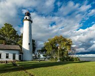
2010-10-16_11-01_06516_WTA_5DM2 Mackinaw Point marks the junction of Lake Michigan and Lake Huron. Founded in 1889, the Old Mackinac Point Light Station was in operation from 1890 until 1957
1 Mackinaw Point marks the junction of Lake Michigan and Lake Huron. Founded in 1889, the Old Mackinac Point Light Station was in operation from 1890 until 1957
WTA_IMG_2011_10_11 - 0376-2 The Round Island Light, also known as the
2 The Round Island Light, also known as the "Old Round Island Point Lighthouse"[5] is a lighthouse located on the west shore of Round Island in the shipping lanes of the Straits of Mackinac,[9] which connect Lake Michigan and Lake Huron. It was deemed necessary because the island is a significant hazard to navigation in the straits, and was seen as an effective complement to the other lights in the area.[10] Because of its color scheme and form — red stone base and wood tower — it has been likened to an old-fashioned schoolhouse.[11] Ferries regularly pass it on their way to (and from) Mackinac Island, and it is a recognizable icon of the upper Great Lakes.
2012-08-30_14-55_10629_WTA_5DM3 Eagle Harbor Light is a lighthouse near Eagle Harbor Township, Michigan on the Keewenaw Peninsula jutting from the Michigan's Upper Peninsula up into Lake...
3 Eagle Harbor Light is a lighthouse near Eagle Harbor Township, Michigan on the Keewenaw Peninsula jutting from the Michigan's Upper Peninsula up into Lake Superior. This area of Michigan is often referred to as Copper Country, and sometimes as Copper Island. That industry helped create interest in the harbor.
2013_02_08-WTA-5DM3-6981-Edit-2 Point Iroquois Light is a lighthouse on a Chippewa County bluff in the U.S. state of Michigan. Point Iroquois and its light mark the division line between...
4 Point Iroquois Light is a lighthouse on a Chippewa County bluff in the U.S. state of Michigan. Point Iroquois and its light mark the division line between Whitefish Bay and the western end of the St. Marys River, the connection between Lake Superior and other Great Lakes.
2013-10-11_11-39_36769_WTA_5DM3 Forty Mile Point Light is a lighthouse in Northern Michigan, in Presque Isle County on Hammond Bay on the western shore of Lake Huron in Rogers Township,...
5 Forty Mile Point Light is a lighthouse in Northern Michigan, in Presque Isle County on Hammond Bay on the western shore of Lake Huron in Rogers Township, Michigan USA. Unlike many Great Lakes lighthouses, Forty Mile Point Light does not mark a significant harbor or river mouth. Rather, it was constructed with the intent that as one sailed from Mackinaw Point to the Saint Clair River, one would never be out of viewing range of a lighthouse.[3] With no river or harbor to use for a name, the light is named on the basis that it is 40 miles (64 km) sailing distance from Mackinaw Poin
G0071368 Mackinaw City Lighthouse
6 Mackinaw City Lighthouse
2015-09-19_79762_WTA_5DSR-Edit The Pointe aux Barques Lighthouse ranks among the ten oldest lighthouses in Michigan. It is an active lighthouse maintained by the US Coast Guard remotely,...
7 The Pointe aux Barques Lighthouse ranks among the ten oldest lighthouses in Michigan. It is an active lighthouse maintained by the US Coast Guard remotely, located in Lighthouse County Park on Lake Huron near Port Hope, Michigan in Huron County. "Pointe aux Barques" means 'Point of Little Boats', a descriptor of the shallow shoals and reefs that lurk beneath these waves, presenting a hazard to boats as they round Michigan's Thumb
2015-09-19_79802_WTA_5DSR-3 The Pointe aux Barques Lighthouse ranks among the ten oldest lighthouses in Michigan. It is an active lighthouse maintained by the US Coast Guard remotely,...
8 The Pointe aux Barques Lighthouse ranks among the ten oldest lighthouses in Michigan. It is an active lighthouse maintained by the US Coast Guard remotely, located in Lighthouse County Park on Lake Huron near Port Hope, Michigan in Huron County. "Pointe aux Barques" means 'Point of Little Boats', a descriptor of the shallow shoals and reefs that lurk beneath these waves, presenting a hazard to boats as they round Michigan's Thumb
2016-07-09_95588_WTA_5DSR_HDR William Livingstone Memorial Light The white fluted marble 70-foot high tower is located on the north end of Belle Isle in the Detroit River. It is the only...
9 William Livingstone Memorial Light
The white fluted marble 70-foot high tower is located on the north end of Belle Isle in the Detroit River. It is the only light in the nation constructed of marble.
Built in 1929 with private donations as a memorial to William Livingstone, who was the president of the Lakes Carriers Association from 1902 to 1925. The plaque on the tower explains that that the light is the gift of the citizens of Detroit and the Lakes Carriers Association.
Livingstone was a popular and prominent resident of Detroit. He is known for his promotion of many navigation improvements on the lakes, including the construction of the separate down-bound channel in the lower Detroit River, which is named after him.
The occulting light is visible for 16 miles to the east. It can be visited and photographed at the north end of Belle Isle in Detroit.
2016-11-19_008767_WTA_5DM4 Grand Haven South Pierhead Inner Light is the inner light of two lighthouses on the south pier of Grand Haven, Michigan where the Grand River enters Lake...
10 Grand Haven South Pierhead Inner Light is the inner light of two lighthouses on the south pier of Grand Haven, Michigan where the Grand River enters Lake Michigan. A lighthouse was first lit there in 1839. The lighthouse was put up for sale in 2009 under the National Historic Lighthouse Preservation Act.[4] The City of Grand Haven now owns the pier, but it is maintained by the Army Corps of Engineers
2016-11-19_009477_WTA_5DM4 Grand Haven South Pierhead Inner Light is the inner light of two lighthouses on the south pier of Grand Haven, Michigan where the Grand River enters Lake...
11 Grand Haven South Pierhead Inner Light is the inner light of two lighthouses on the south pier of Grand Haven, Michigan where the Grand River enters Lake Michigan. A lighthouse was first lit there in 1839. The lighthouse was put up for sale in 2009 under the National Historic Lighthouse Preservation Act.[4] The City of Grand Haven now owns the pier, but it is maintained by the Army Corps of Engineers
2016-11-19_009604_WTA_5DM4 Grand Haven South Pierhead Inner Light is the inner light of two lighthouses on the south pier of Grand Haven, Michigan where the Grand River enters Lake...
12 Grand Haven South Pierhead Inner Light is the inner light of two lighthouses on the south pier of Grand Haven, Michigan where the Grand River enters Lake Michigan. A lighthouse was first lit there in 1839. The lighthouse was put up for sale in 2009 under the National Historic Lighthouse Preservation Act.[4] The City of Grand Haven now owns the pier, but it is maintained by the Army Corps of Engineers
2016-11-19_009843_WTA_5DM4 Grand Haven South Pierhead Inner Light is the inner light of two lighthouses on the south pier of Grand Haven, Michigan where the Grand River enters Lake...
13 Grand Haven South Pierhead Inner Light is the inner light of two lighthouses on the south pier of Grand Haven, Michigan where the Grand River enters Lake Michigan. A lighthouse was first lit there in 1839. The lighthouse was put up for sale in 2009 under the National Historic Lighthouse Preservation Act.[4] The City of Grand Haven now owns the pier, but it is maintained by the Army Corps of Engineers
2016-11-19_011057_WTA_5DM4 The Muskegon Breakwater Light or South Breakwater Light is a light located on the end of the south arm of the Muskegon breakwater surrounding the mouth of the...
14 The Muskegon Breakwater Light or South Breakwater Light is a light located on the end of the south arm of the Muskegon breakwater surrounding the mouth of the Muskegon channel in Muskegon, Michigan.
The site is accessible by walking the breakwater. As of Summer, 2015, the light is available to the public for tours.
In 2008 the light became available for transfer under NHLPA, and in June 2010 ownership was transferred to the Michigan Lighthouse Conservancy. The lights and buoys of Muskegon Harbor are maintained by the US Coast Guard Station housed in the lighthouse 3/8 of a mile away, at the mouth of the Muskegon Channel. The light has been in service since 1879.
2016-11-19_011586_WTA_5DM4-Edit-2 The Muskegon Breakwater Light or South Breakwater Light is a light located on the end of the south arm of the Muskegon breakwater surrounding the mouth of the...
15 The Muskegon Breakwater Light or South Breakwater Light is a light located on the end of the south arm of the Muskegon breakwater surrounding the mouth of the Muskegon channel in Muskegon, Michigan.
The site is accessible by walking the breakwater. As of Summer, 2015, the light is available to the public for tours.
In 2008 the light became available for transfer under NHLPA, and in June 2010 ownership was transferred to the Michigan Lighthouse Conservancy. The lights and buoys of Muskegon Harbor are maintained by the US Coast Guard Station housed in the lighthouse 3/8 of a mile away, at the mouth of the Muskegon Channel. The light has been in service since 1879.
2016-11-19_097609_WTA_5DM4 The Muskegon Breakwater Light or South Breakwater Light is a light located on the end of the south arm of the Muskegon breakwater surrounding the mouth of the...
16 The Muskegon Breakwater Light or South Breakwater Light is a light located on the end of the south arm of the Muskegon breakwater surrounding the mouth of the Muskegon channel in Muskegon, Michigan.
The site is accessible by walking the breakwater. As of Summer, 2015, the light is available to the public for tours.
In 2008 the light became available for transfer under NHLPA, and in June 2010 ownership was transferred to the Michigan Lighthouse Conservancy. The lights and buoys of Muskegon Harbor are maintained by the US Coast Guard Station housed in the lighthouse 3/8 of a mile away, at the mouth of the Muskegon Channel. The light has been in service since 1879.
2017-04-21_05918_WTA_Phan4Pro Point Betsie Light is located on the northeast shore of Lake Michigan — at the southern entrance to the Manitou Passage — north of Frankfort in Benzie County in...
17 Point Betsie Light is located on the northeast shore of Lake Michigan — at the southern entrance to the Manitou Passage — north of Frankfort in Benzie County in Northern Michigan. Construction began in 1854, but it was not completed until 1858, and began service in the shipping season of 1859. The lighthouse cost $5,000 to build. In 1875, a life saving station was built for $3,000.
2017-04-22_12896_WTA_5DM4-Edit Mission Point Lighthouse
18 Mission Point Lighthouse
2017-04-22_06000_WTA_Phan4Pro Mission Point Light is a lighthouse located in the U.S. state of Michigan at the end of Old Mission Point, a peninsula jutting into Grand Traverse Bay 17 miles...
19 Mission Point Light is a lighthouse located in the U.S. state of Michigan at the end of Old Mission Point, a peninsula jutting into Grand Traverse Bay 17 miles (27 km) north of Traverse City. When it was built in 1870, it was an exact copy of the Mama Juda Light (now destroyed), which was built on the Detroit River in 1866.
The foundation is natural and emplaced. The wooden structure is painted white with black trim. The square tower is attached to a dwelling.
A fixed white Fifth Order Fresnel lens was installed. The building was only one and one half stories tall. However, its placement on a sand bank 14 feet above the lake's surface created a lens focal plane of 47 feet (14 m). It was visible from 13 miles (21 km)[citation needed] at sea. Maintaining the dune and protecting it and the lighthouse from the deleterious effects of wave action has been a constant struggle.
For 67 years the light served to warn mariners about the shoals off the point. However, new techniques in offshore construction and the automation of lighthouse illumination made it possible to build a navigation aid on the shoal itself. In 1938, work began on a pier for the new light in 19 feet (5.8 m) of water, about 2 miles (3.2 km) northwest of Mission Point. The light ran on batteries. It was on a 36-foot (11 m) tall tower, and its focal plane of 52 feet (16 m) help make it visible for 13 miles (21 km). It had a 30-second dwell time between flashes, in order to conserve power.
Famously, the lighthouse stands a few hundred yards south of the 45th parallel north, halfway between the North Pole and the Equator. The lighthouse was deactivated in 1933 and purchased by the State of Michigan. There are a pair of signs that denote its location on the parallel, and it is one of 29 places (six are in Michigan) in the U.S.A. where such signs are known to exist.
2017-07-16_27433_WTA_5DM4
20

New images